
3D coastal models
Your coast and your reef, crafted into something a guest can walk up to and hold.
For hotels, resorts and visitor centres
Read moreSeabed intelligence and marine solutions.
The sea holds an entire world that cannot be seen from the shore. LUJJAH Tech turns scientific marine data into experiences people can actually see, hold, and use.
Your coast and your reef, crafted into something a guest can walk up to and hold.
For hotels, resorts and visitor centres
Read moreYour phone becomes your eyes underwater. Reveal the seabed through your camera.
For waterfronts, marinas, beaches and dive centres
Read moreEvery beach, dive site and sea condition in one app. The gate to the sea.
For divers, boat owners, fishermen and coastal visitors
Read moreWater quality, hydrography and change beneath the surface, measured and explained.
For regulators, consultancies, ports and coastal developments
Read moreSome things are better held than described.
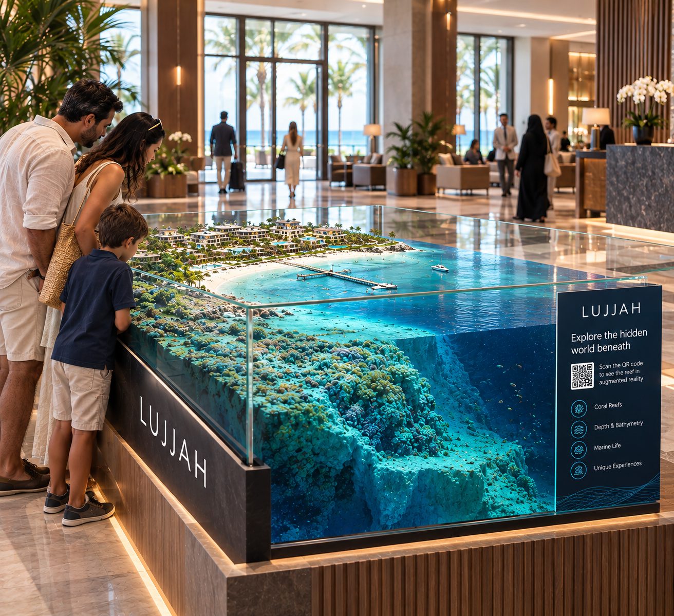
Survey data and underwater imaging become a detailed physical model that brings the underwater landscape into the room. Set on a reception desk or a conference table, it shows the relationship between coastline, seabed, reef and depth without a single line of explanation.
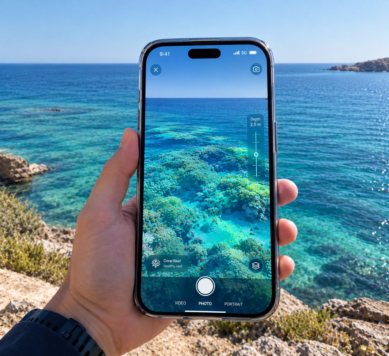
Your phone becomes your eyes underwater.
LUJJAH Tech turns survey data and underwater imaging into an augmented reality experience. A visitor points their phone at a banner, and the camera shows what the sea is hiding: the reef, the seabed, the depth beneath their feet. No mask. No boat. No certification. Just a phone and a shoreline.
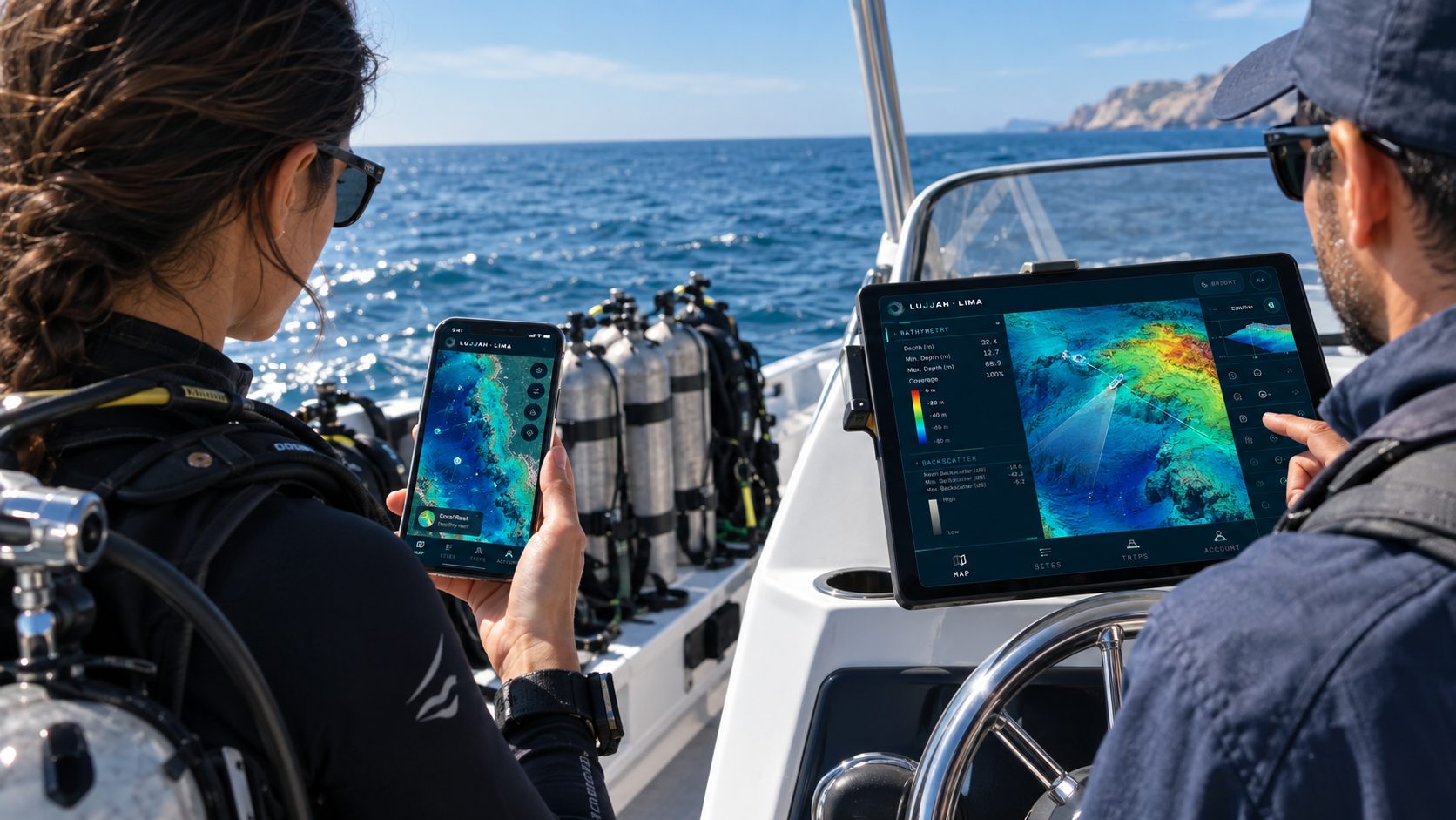
Every beach, dive site and sea condition in one app.
LIMA brings beaches, offshore environments, diving locations, marine activities and sea conditions into one place. Instead of searching across scattered sources for information about the sea, everything sits in one platform, before the journey, during it, and at the destination.
Each one opens more of the catalogue, from locations at the surface to the whole survey record. Every tier contains the one before it.
Locations and conditions
LIMA GO included
LIMA NAV included. The full pack.
LUJJAH Tech measures the marine and coastal environment to understand its condition, its character and how it changes.
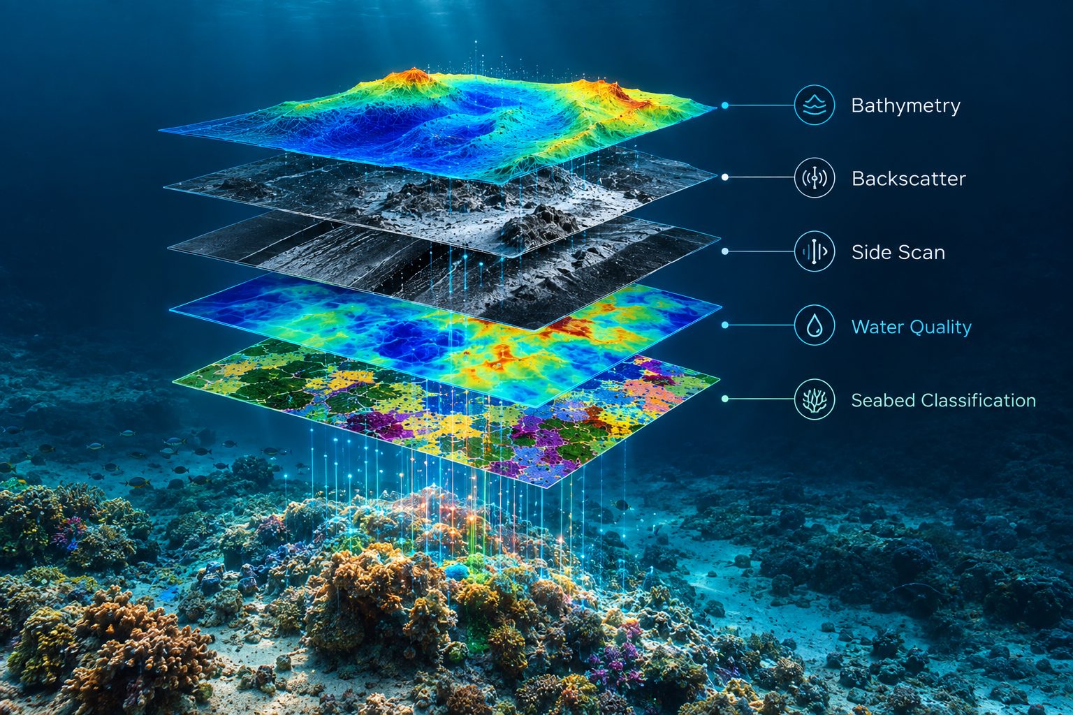
LUJJAH Tech combines field measurements, hydrographic surveys, underwater observations and environmental data to create a clear understanding of marine environments and how they change over time.
Every beach, dive site and sea condition in one app. LIMA is a phone app first, and it works on a tablet too.
For everyone who treats the sea as a destination. Divers and dive operators, boat owners and fishermen, swimmers and visitors along the coast.
Sites, conditions and sea state in one place, with the source of every figure stated, so that the person on the water decides for themselves.
The platform reports conditions. It does not issue verdicts. The decision stays with the professional on site.
Each one opens more of the catalogue, from locations at the surface to the whole survey record. Every tier contains the one before it.
Lifetime access. Locations and conditions.
Free while LIMA is in preview. LIMA GO included. Not for navigation.
Free while LIMA is in preview. LIMA NAV included. The full pack.
One operation, many answers. LUJJAH Tech measures the marine and coastal environment to understand its condition, its character and how it changes.
LUJJAH Tech combines field measurements, hydrographic surveys, underwater observations and environmental data to create a clear understanding of marine environments and how they change over time.
Every result carries its method, standard, date and uncertainty. Change is reported between stated epochs. Where a result is relative rather than absolute, it says so.
No deliverable is a certified chart and none of it is for navigation. Client data stays confidential and is never published to the platform without written agreement.
Depth and the shape of the seabed.
Water quality, currents, waves and water level.
Divers, ROVs and AUVs, combined into mosaics and models.
Every item keeps its source, standard, date and uncertainty.
LUJJAH Tech does not own a fixed fleet of sensors. Systems are specified and mobilised against the job in front of us, so the survey is matched to the water depth, the seabed and the question being asked rather than to whatever is sitting in a store.
The permanent asset is the platform. The data, the processing chain and the way results are delivered stay with LUJJAH Tech between projects, and the application built on top of them is the second product.
Some things are better held than described. LUJJAH Tech turns survey data and underwater imaging into detailed physical models that bring the underwater landscape into the room.
Stand on the shore. Scan the code. Watch the water fall away. LUJJAH Tech turns survey data and underwater imaging into an augmented reality experience. A visitor points their phone at a banner, and the camera shows what the sea is hiding.
Four offerings, three different rooms they belong in.
For organisations responsible for what happens beneath the surface. Government bodies and regulators that need defensible evidence, environmental consultancies and research institutions that need measurements with their method attached, and marine industry operators, ports, harbours and coastal developments, that need to know what the seabed is doing before they build on it or dredge it.
For coastal venues and visitor spaces. Hotels and resorts, dive centres and dive resorts, and public coastal places such as waterfronts, marinas and beaches. A guest sees the shoreline above the water. The model puts what lies below it in front of them, in a form they can walk up to, and Underwater Reveal does the same through a phone camera, for the far larger number of people who will never put on a mask.
For everyone who treats the sea as a destination. Divers and dive operators, boat owners and fishermen, swimmers and visitors along the coast. Sites, conditions and sea state in one place, with the source of every figure stated, so that the person on the water decides for themselves.
Seabed data has always been delivered in a form only a specialist can open. Charts, soundings, files that end their life on a hard drive. We collect the same data to the same standard, then hand it over as something a port, a regulator, a dive centre or a visitor can actually use.
To make the seabed legible. The rigour stays exactly where it is. What changes is the way the result reaches the person who has to act on it.
A living map of the seabed beneath Saudi waters. Measured once, understood fully, and watched over time.
Survey in full, report honestly, and keep watching. Depth, seabed character, coverage and the limits of what was measured, delivered as standard rather than sold back piece by piece.
To become the reference source for seabed data in Saudi waters, working with clients over years rather than delivering one survey and leaving.
One survey, many products. A single acquisition feeds both the monitoring record and the public platform, so nobody pays twice for the same seabed.
A named person stands behind every claim. Provenance, method and confidence travel with the data itself, so any result can be traced back and audited independently.
Run and reported against IHO standards, with coverage, accuracy and uncertainty stated on the product. Where a result is relative rather than absolute, it says so.
Repeat monitoring of the same ground replaces repeated mobilisation. Baseline and change data support reef protection, dredging control and coastal planning.
Collect depth, water and imaging data on site.
Check every measurement against its stated standard.
Describe the seabed and the water as they are.
Set each survey against the ones before it.
Identify what has moved, grown or declined.
Deliver the result in the form the client needs.
What we state is true, including the parts that cost us.
Method and limits are visible before anyone asks.
A non-surveyor can read the deliverable and act on it.
We sign the result. If it is wrong, you hear it from us first.
Completed surveys will be published here with the area, the standard they were run to and the uncertainty they carry. Nothing appears on this page until it is real and the client has agreed to it being shown.
First case studies in preparation.
Its root turns on abundance, surging, height and intensity. The lexicons give the word four senses at once, and every one of them describes part of this company.
| Aquatic | The deep abyss of the sea, thick surging water whose bottom cannot be reached | The subject |
|---|---|---|
| Acoustic | Clamour, roaring, the tumult of crashing waves | The method |
| Visual | Overwhelming dense darkness, a mass that covers the horizon | The obstacle |
| Figurative | Immersion, being in the thick of something vast | The positioning |
The second and third senses are why this name beats a chosen one. The word means both deep water and sound. We measure the deep sea using sound, in a place where light does not reach. The name states the business before a single word of marketing is written.

A vortex drawn as motion rather than outline. Arcs spiral inward and resolve toward a still centre, so it reads three ways at once: a whirlpool, a sounding sweep, and depth seen from above.
Accountability means a name.

Hydrographic surveyor and quality management professional, with over eight years across leading Saudi organisations in marine surveying, underwater robotics and operational quality.
Khalid Abulkhair is a seasoned quality management professional, IHO CAT-A Hydrographic Surveyor, certified ROV Pilot, and PADI Rescue Diver with over 8 years of progressive experience across Saudi Arabia's leading organizations. His career spans senior technical and leadership roles at a top oil and gas company and prominent PIF portfolio entities, where he has driven QA/QC frameworks, environmental monitoring programs, and operational quality systems at scale.
Currently serving as a Projects Quality Manager, he leads the establishment of quality control functions, governance structures, and digital inspection platforms across major venue operations. With deep expertise in marine surveying, underwater robotics, and stakeholder engagement, Khalid brings a blend of technical depth and strategic leadership to the work.
Kingdom of Saudi Arabia. Operations, processing and delivery run from here.